FusionMaps with ASP > Using dataXML Method
We'll cover the following examples here:
- Rendering map from array using dataXML Method.
- Rendering map from array using dataURL Method.
- Rendering map using Form based data and
- Rendering drill-down maps pulling data from database.
- Here we will first declare an array and store data in it.
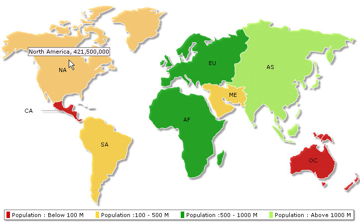
- Then we will build the map XML by fetching data from the array.
- Finally, we will relay the data in XML format to FusionMaps to render the map.
<%@ Language=VBScript %>
<%
'We've included ../Includes/FusionMaps.asp, which contains functions
'to help us easily embed the maps.
%>
<!-- #INCLUDE FILE="../Includes/FusionMaps.asp" -->
<HTML>
<HEAD>
<%
'We've included FusionMaps.js, which helps in JavaScript map embedding.
%>
<script type="text/javascript" language="javascript" src="../JSClass/FusionMaps.js"></script>
</HEAD>
<BODY>
<%
'Declare array to store world population
' we use world map with 8 entities/continents
' this 2 dimensional array will store 8 rows of data for each continent of the map
' first column of each row will store the Internal Id of each entity on the map
' second column will store population data of each entity
dim dataArray(8,2)
'Store population data
dataArray(1,1)="01" ' Internal ID of Asia
dataArray(1,2)="3779000000" ' Asia's population
dataArray(2,1)="02" ' Internal ID of Europe
dataArray(2,2)="727000000"'population
dataArray(3,1)="03"' Internal ID of Africa
dataArray(3,2)="877500000"'population
dataArray(4,1)="04"' Internal ID of North America
dataArray(4,2)="421500000"'population
dataArray(5,1)="05"' Internal ID of South America
dataArray(5,2)="379500000"'population
dataArray(6,1)="06"' Internal ID of Central America
dataArray(6,2)="80200000"'population
dataArray(7,1)="07"' Internal ID of Oceania
dataArray(7,2)="32000000"'population
dataArray(8,1)="08"' Internal ID of Middle East
dataArray(8,2)="179000000"'population
'Declare strXML to store dataXML of the map
dim strXML
'Opening MAP element
strXML = "<map borderColor='FFFFFF' fillAlpha='80' showBevel='0' legendPosition='Bottom' >"
'Setting Color ranges : 4 color ranges for population ranges
strXML = strXML & "<colorRange>"
strXML = strXML & "<color minValue='0' maxValue='100000000' displayValue='Population : Below 100 M' color='CC0001' />"
strXML = strXML & "<color minValue='100000000' maxValue='500000000' displayValue='Population :100 - 500 M' color='FFD33A' />"
strXML = strXML & "<color minValue='500000000' maxValue='1000000000' displayValue='Population :500 - 1000 M' color='069F06' />"
strXML = strXML & "<color minValue='1000000000' maxValue='5000000000' displayValue='Population : Above 1000 M' color='ABF456' />"
strXML = strXML & "</colorRange>"
'Opening data element that will store map data
strXML = strXML & "<data>"
'Using Data from array for each entity
FOR i=1 TO ubound(dataArray)
strXML = strXML & "<entity id='" & dataArray(i,1) & "' value='" & dataArray(i,2) & "' />"
NEXT
'closing data element
strXML = strXML & "</data>"
'closing map element
strXML = strXML & "</map>"
'Create the Map - using strXML as dataXML string;
Call renderMap("../../Maps/FCMap_World8.swf", "", strXML, "firstMap", 750, 460,0,0)
%>
</BODY>
</HTML>
- FusionMaps.asp
- FusionMaps.js
<HTML>
<HEAD>
...
<script type="text/javascript" language="javascript" src="../JSClass/FusionMaps.js"></script>
...
These two files contain functions to embed the map easily.
dim dataArray(8,2)
'Store population data
dataArray(1,1)="01" ' Internal ID of Asia
dataArray(1,2)="3779000000" ' Asia's population
dataArray(2,1)="02" ' Internal ID of Europe
dataArray(2,2)="727000000" 'population
dataArray(3,1)="03"' Internal ID of Africa
dataArray(3,2)="877500000"'population
dataArray(4,1)="04"' Internal ID of North America
dataArray(4,2)="421500000"'population
dataArray(5,1)="05"' Internal ID of South America
dataArray(5,2)="379500000"'population
dataArray(6,1)="06"' Internal ID of Central America
dataArray(6,2)="80200000"'population
dataArray(7,1)="07"' Internal ID of Oceania
dataArray(7,2)="32000000"'population
dataArray(8,1)="08"' Internal ID of Middle East
dataArray(8,2)="179000000"'population
dim strXML
'Opening MAP element
strXML = "<map borderColor='FFFFFF' fillAlpha='80' showBevel='0' legendPosition='Bottom' >"
strXML = strXML & "<colorRange>"
strXML = strXML & "<color minValue='0' maxValue='100000000' displayValue='Population : Below 100 M' color='CC0001' />"
strXML = strXML & "<color minValue='100000000' maxValue='500000000' displayValue='Population :100 - 500 M' color='FFD33A' />"
strXML = strXML & "<color minValue='500000000' maxValue='1000000000' displayValue='Population :500 - 1000 M' color='069F06' />"
strXML = strXML & "<color minValue='1000000000' maxValue='5000000000' displayValue='Population : Above 1000 M' color='ABF456' />"
strXML = strXML & "</colorRange>"
strXML = strXML & "<data>"
'Using Data from array for each entity
FOR i=1 TO ubound(dataArray)
strXML = strXML & "<entity id='" & dataArray(i,1) & "' value='" & dataArray(i,2) & "' />"
NEXT
'closing data element
strXML = strXML & "</data>"
'closing map element
strXML = strXML & "</map>"
Call renderMap("../../Maps/FCMap_World8.swf", "", strXML, "firstMap", 750, 460,0,0)
| Parameter | Description |
| mapSWF | SWF File Name (and Path) of the map which we want to plot. Here, we are plotting a World (having 8 continent segments) Map. So, we've specified it as ../../Maps/FCMap_World8.swf |
| strURL | If we use dataURL method to plot data over maps, we have to pass the URL as this parameter. Else, set it to "" (in case we use dataXML method). In this case, we're using data XML method, hence we kept it blank. |
| strXML | If we use dataXML method to plot data over maps, we have to pass the XML data as this parameter. Else, set it to "" (in case we are using of dataURL method). In this case, we're using dataXML method, hence we passed strXML through this field. |
| mapId | The ID for the map by which it will be recognized in the HTML page. If we use multiple maps on the same page, then all the maps should have unique mapId. |
| mapWidth | Intended width for the map (in pixels) |
| mapHeight | Intended height for the map (in pixels) |
| debugMode | Whether to start the map in debug mode. Please see Debugging your Maps section for more details on Debug Mode. |
| registerWithJS | Whether to register the map with JavaScript. |
